
Hydrologic modelling of the Olsbækkens catchment
The catchment is located in the Greve municipality, southwest of Copenhagen. Streams Hederenden and Olsbæk carry water from east to west towards the Køge Bay. Godsparken is a neighborhood in a lower area of the catchment, where water tends to accumulate after heavy rain.
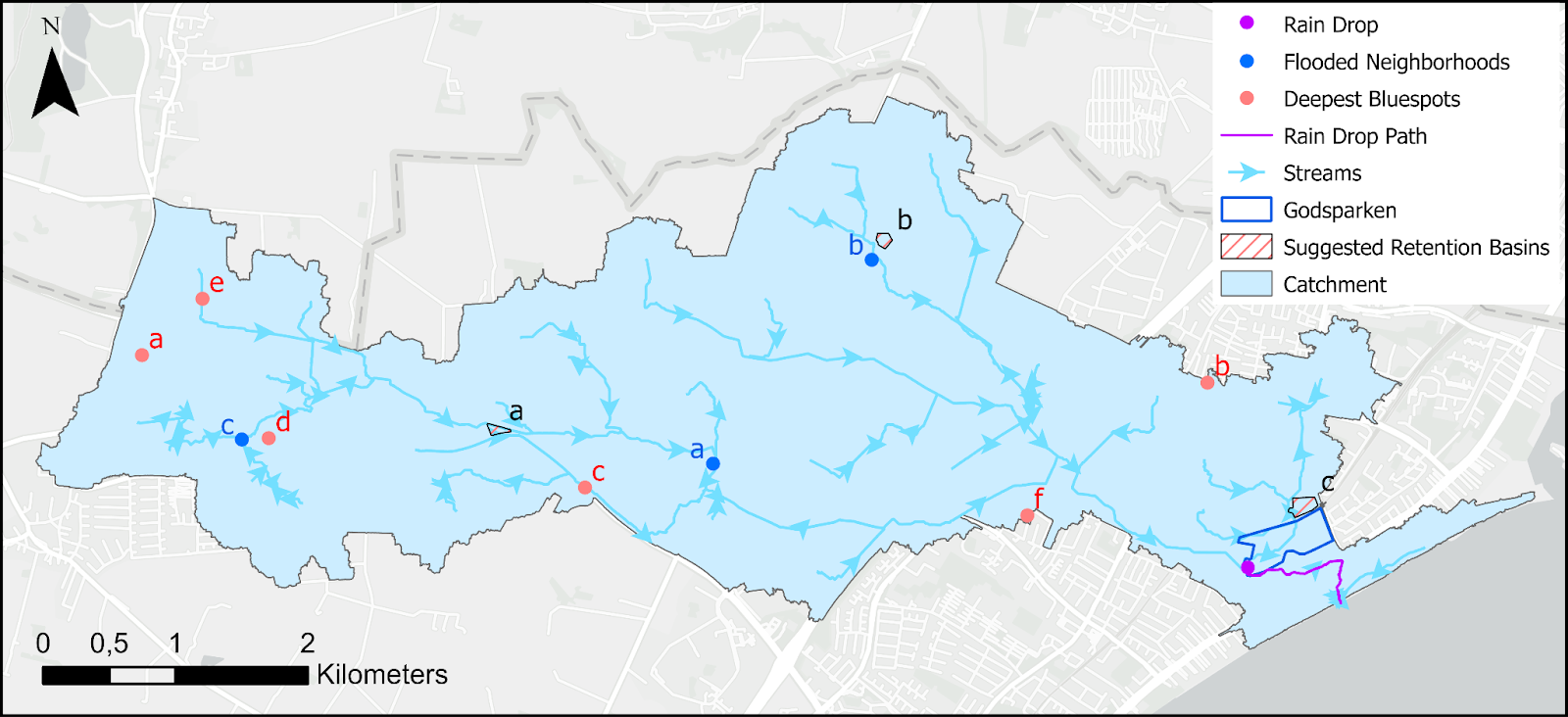 Figure 1. The overview of Olsbækkens catchment.
The project utilised the Malstroem model and ArcGIS Pro ModelBuilder. It was completed together with Miki Yamamoto as a part of MSc course in January 2024.
Flooded buildings
We identified buildings vulnerable to various magnitude of stormwater events based on the different spatial relationships between buildings and bluespots.
Table 1. The number of buildings affected by the filled bluespots after a certain rain event (mm).
| 30 mm | 40 mm | 50 mm | 60 mm | 70 mm | 80 mm | 90 mm | 100 mm | |
|---|---|---|---|---|---|---|---|---|
| completely within | 192 | 329 | 433 | 444 | 596 | 599 | 601 | 704 |
| intersect | 2525 | 2847 | 3040 | 3080 | 3360 | 3375 | 3392 | 3606 |
We created a model to locate the buildings within the catchment that can potentially get flooded during various stormwater events. First, it selects the bluespots, which get filled during a certain rain event (30-100 mm). Then, it finds all the buildings that are located either completely within or intersect with the certain bluespots. Lastly, the selected features are copied and displayed.
In addition to Godsparken, we identified three neighborhoods, which get flooded during a frequent stormwater event (30 mm). The locations within the catchment are shown in Figure 1 (blue points) and the close-ups to the neighborhoods are in Figure 2:
a. Greve Landsby, bluespot spill is 40 760,16 m3;
b. Kildebrønde, bluespot spill is 24 196,58 m3;
c. Tune (Mimosevej), bluespot spill is 8662,97 m3.
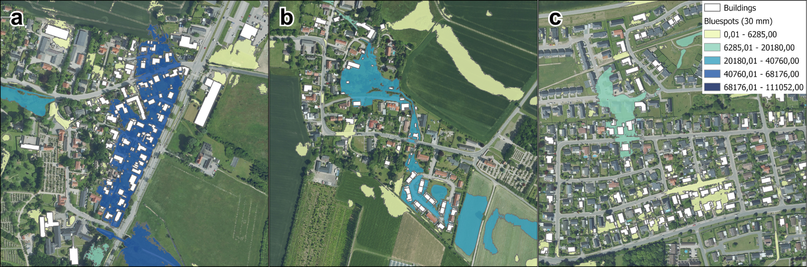 Figure 2. Vulnerable neighborhoods of Greve municipality in case of a 30 mm stormwater event. Background: orthophoto from summer 2022.
Suggestions for new retention basins
We suggest to build retention basins in three vulnerable locations as shown in Figure 3. The locations A (near Greve Landsby) and B (in Kildebrønde) were selected based on their proximity to the significant streams and placement upstream of critical bluespots, expecting to store rain water before flowing into the residential areas. These streams would carry a high volume in case of a 60 mm rainfall event, hence these neighborhoods are at high risk of severe damage by heavy or intermediate scale floods.
For the location C, in a neighborhood north of Godsparken, it is contrarily suggested to locate the retention basin downstream, as it is difficult to identify the significant stream in the built-up area. The basin is expected to store rain water leveraging the mechanism that water flows from higher point to the lower point by constructing additional water flow redirection. At a 60 mm rainfall event, the streams would have comparatively low volume. However, this neighborhood has higher population density than the other two, so even a smaller scale flood can cause significant damage.
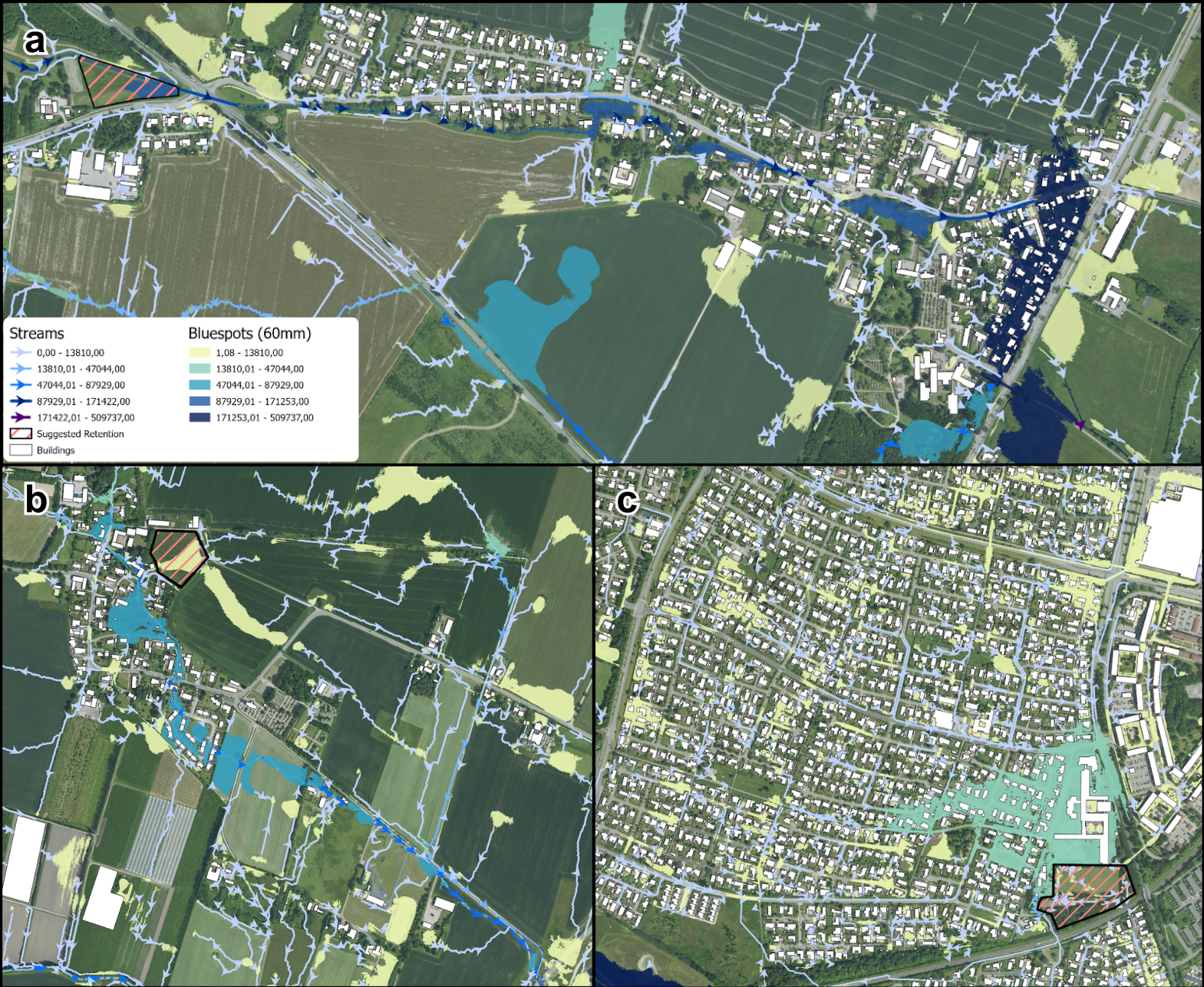 Figure 3. Three suggestions for the new retention basins based on the locations of streams and bluespots in case of a 60 mm rainfall event.
Background: orthophoto from summer 2022.
Figure 3. Three suggestions for the new retention basins based on the locations of streams and bluespots in case of a 60 mm rainfall event.
Background: orthophoto from summer 2022.